Please remember that I do recognize that there are several types of detectorist ranging from those that just love to be out in the fresh air and dream about finding history but are also happy with their lot to those that require a structured and measured approach, therefore fully utilizing precious time spent in the field. There are of course those in between the two.
The structured approach applies to our team as we don’t have the premium history on our doorstep such as Lincolnshire, Norfolk and Wiltshire for example. We have to travel up to six hours which is a lot of time spent not detecting so that when we do arrive at our sites we have a plan, usually three or more to be exact. We would love it if our sites were a lot closer, just think, we’d have 5 hours extra to detect or better still, have a lie-in!
This post is only intended for those that might want the challenge of a different approach to the way they detect new land.
Background
Now that we have an established method of measuring a field in two dimensions; area and time, we have a basis on what to expect when we reach our search spot. The following applies to private permissions and not rallies or club digs for obvious reasons. All times stated are the absolute minimum times.
We now know the minimum time it will take to search your field so if it’s a 9-hour field, i.e. 2 acres and you spend one hour searching it, you know you’ve only covered a ninth of it at the most.
It doesn’t matter which way you cut it up, whether that be working in exact and precise lines or wandering around in a totally unorganized manner, you will only cover a ninth of the field in one hour at the most - fact.
It doesn’t take much to work out that you still have another eight sections of that field to search using either method. As shown in the “Time Estimation” post it is impossible to cover any more in the time allowed as this will result in zig-zagging and lost ground coverage and therefore missed signals.
If you return to that field at a later date, you will know exactly where you’ve been when using the precise line method. On the other hand, using the random wandering method, you won’t have much of a clue as to what ground you’ve covered. This is amplified when there two or more detectorists using this method. There will only be disturbed soil at various random locations without any indication as to which direction was taken when arriving at the “hole” and indeed, as to which direction you left that “hole”. This will result in covering ground already searched. If you do find something, then the answer is simply; it wasn’t covered sufficiently - fact.
I should know about this as we were on a field in which the drilled crop changed direction in two ways; a strange mixed curved and a straight-on direction. This resulted in two sets of crop lines going in different directions and also resulted in a small missed area. The item missed (hence the 99% recovery rate) was a huge Medieval key that was only three inches deep. There can’t be any other reason for missing the key, not the following reasons; i.e. ground conditions, target orientation, mineralization, interference etc etc etc etc etc (the list is endless).
This just goes to prove that if you can’t search methodically, large items will be missed, never mind small “hammies” and other small items!
The key here (no pun intended) is aiming for 100% coverage whatever method you use. This results in a high recovery rate for us and will be repeated the following year, unless the field was only drilled and not ploughed.
The Union Jack Method
This brings us to the tried and tested “Union Jack” method used by some detectorists on a new field.
The way I understand it is that this method will quickly give you a flavour of the history that might exist in that particular field? If you don’t find much, you can then decide to forget that field and move on to another field or area altogether.
I’m aware that some detectorists do not use this method and wander around hoping to find a hot-spot. That is fair enough but at least there is some structure to the Union Jack method in knowing where you’ve been!
There is no wrong or right way whatever method you use as long as you’re happy.
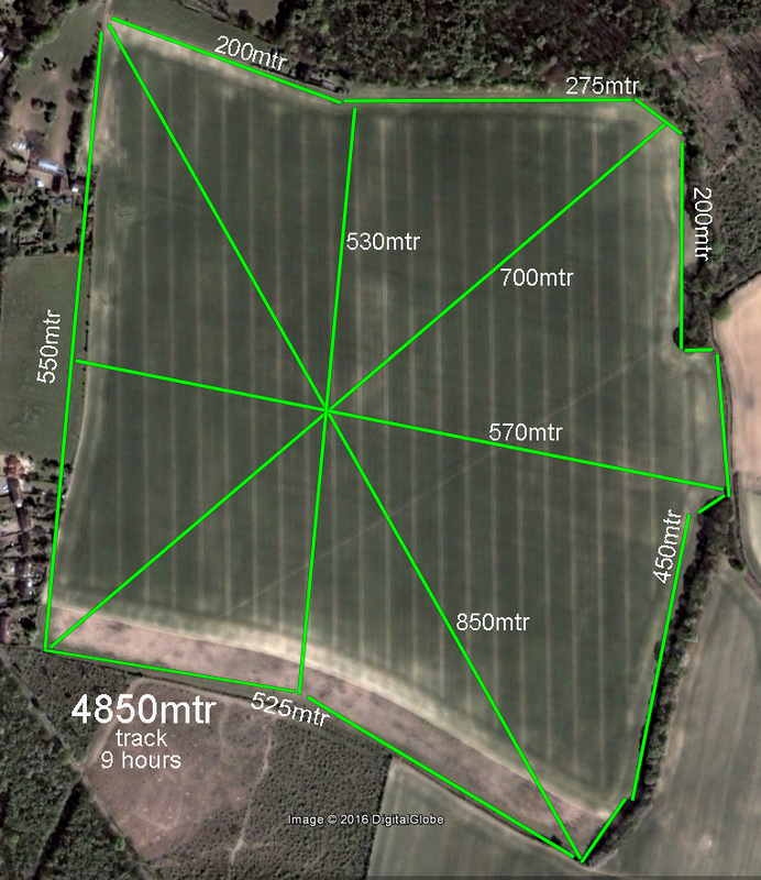
Below is an image of a 77-acre field in Kent chosen at random. Using the time estimate calculation shows that it will take a minimum of 346 hours for one person to search fully ie, 100% coverage.
The standard “Union Jack” method will take a minimum of 9 hours for one person to cover all of the green lines which total 4850 metres of travel. So, using our example explained in the “background” section above; if you spent just an hour in this field you will have only covered a ninth of the Union Jack coverage in total at the most.
As you can see, there are large areas that are missed, but however, there is a concentration or focus point in the centre of the field. As you move outwards the missed areas grow larger.
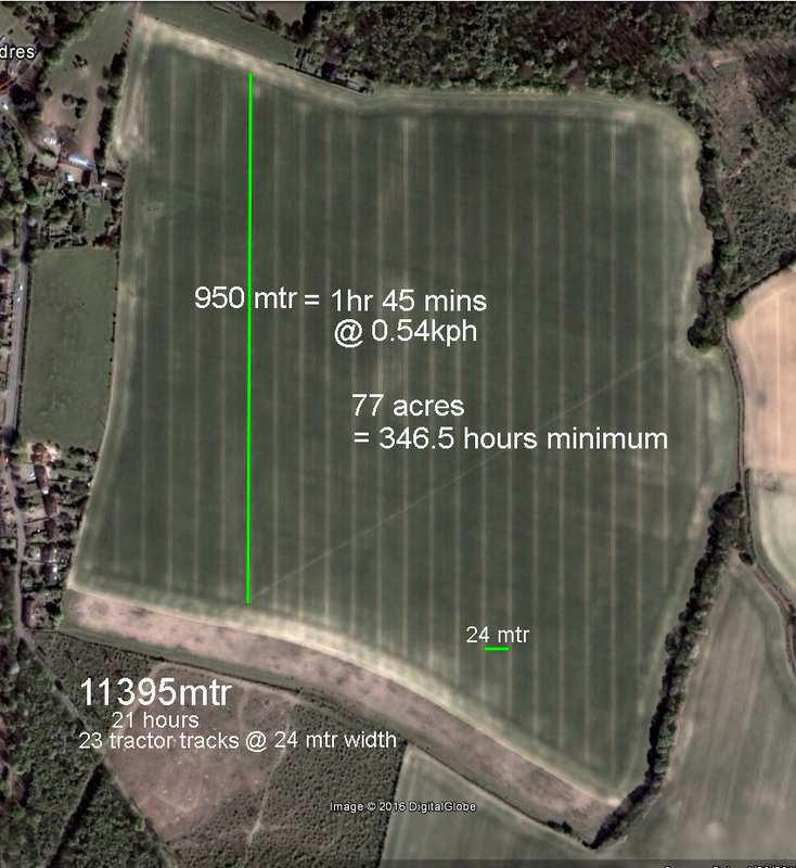
Our version of the “Union Jack” method utilizes the tractor tracks that are used when spraying the crop during growth. These tractor tracks are usually 24 metres apart (depending on spray boom width) and are accurate to 20mm (left/right) where the farmer has used highly accurate industry standard GPS.
Knowing it will take a minimum of 346 hours for one person to search fully, you can instead split it into 24-metre-wide segments marked by the tractor tracks. This will reduce the time dramatically whilst still cutting through accurate swathes of the field. As you can see, there are 23 of these tractor tracks running north-south in this example. If there are three of you, each can choose a line and when completed leap frog to the next line and so on.
One person would take 21 hours’ minimum to cover the 23 lines, that is 11395mtrs in travel. Three people would take 7 hours (a detecting day almost) to do the same but in doing so will have built up a good picture of what is or isn’t there. If after covering the 23 tracks, you don’t find lots of pottery or indeed don’t get many signals you know that there is little evidence of habitation or use there.
You do have further options; you can miss every other tractor line ie 48 metre swathes (or as many as you like) but run the risk of possibly missing something such as a roundhouse or small farmstead.
You will still cover more ground than the standard Union Jack method. In fact, you’d have to cut back the tractor lines by almost 2.5 times to equal the standard Union Jack coverage of 4850 metres which would be about 9 of the tractor lines, of your choice of course.
You can then decide whether or not to carry on searching this field or move on to another field, just as you would be using the standard Union Jack method. That is entirely your choice.


 RSS Feed
