It’s a true and widely accepted fact that “You’ve got to walk over it to find it".
The ability to achieve this fact is quite simple, the field must be covered in its entirety, without exception, or targets will certainly be missed, but how long would this realistically take?
The larger your permissions the longer it's going to take to search, but rushing a search will surely result in many missed artefacts or coins?
The PAST team have been forced to look at our permissions critically, decide what we can actually search effectively and how long that may take. The results have shown us that we aren't going to survey quite as much as we'd hoped and that some permissions and projects may have to be dropped for a while to accommodate the newer permissions that have superceded them!
First of all, try this experiment, ask your partner to mark 12 dots (hammered coins?) with a biro anywhere on an A4 sheet of paper, this can ‘represent’ a one-acre field for instance.
Without looking, trace your search path around the “field” with the same biro and when you think you’ve finished “searching” have a look at how many of the 12 dots you hit. Imagine if this was a ten-acre field! Hopefully this may show just how easy it is to miss finds! And, the biro dot will be much larger in proportion than a hammered coin too!
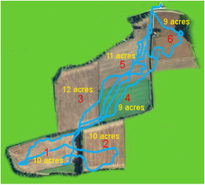
Below is the actual path of a detectorist (left image) tracked by GPS through a total area of 61 acres comprising of 6 fields or 246,859m² over one day. That's 8 times larger than our sample field (See "The PAST Sample Field" featured below) which required a day and-a-half for the team to complete. As can be seen, several large areas have been missed.
Good luck indeed would have to be on your side to hit targets using the pattern in the left-hand image.
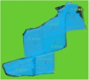
The coverage in right-hand image would take at least 11 ½ days for the team to complete, or 34 days for a single detectorist. The right-hand image represents what would be the PAST teams’ total search coverage if we were to search those fields. However, it would be bad luck to miss anything using the search system in the right hand image (coverage shown in blue) as 99% of in-range targets would be recovered.
- Field or area size (acreage/m²/hectares)
- Coil size (area m²)
- Sweep width (outer edge of coil - left to right)
- Sweep speed (left to right)
- Pace/speed (maximum forward momentum to match coil size and sweep width without "zig-zagging")
- Survey time in hours per visit
- Target density
The PAST Sample Field
This example is a field that we surveyed recently over a day and-a half and recovered 12 hammered coins and Roman artefacts. The field size was 7 ¾ acres and the large 13" x 11" Déus coils were used:
- 7.73 acres = 31300 mtr² (calculated using Google Earth Pro)
- Coil size 13" x 11" (33cm x 28cm) = 143 inches sq or 0.092m²
- Sweep width* and distance forward* @ 1.66 mtr x 1.66 mtr = 2.76 mtr²*
- 11 seconds (timed) to cover 2.76 mtr² = 0.56mph or 0.9km/hour
- 8-hours per day (limited by daylight)
Being a perfect world (sic), I’ve eliminated the target density.
The equation for one person covering a field would be:
fieldm²/coil swing width²* x time/min’s/hours/daylength
31300/2.76* x 11/60 = 2079 minutes
31300/2.76* x 11/60/60 = 34.65 hours
31300/2.76* x 11/60/60/8 = 4.33 days
31300m² = 339258 x 13" x 11" coils
31300m² = 598928 x 9" coils
*This parameter is dependent on the individuals sweep width and of course can vary. The wider the sweep, the slower the forward momentum should be to account for this. Once an individual's coverage is measured this can then be used in the equation but the overall timings shouldn't be too far off the results above.
So, one person with the large 13" x 11" coil should take nearly four and a half days to complete a survey of this field at the earliest and that's excluding any signals or digging!
In essence, it would take one person four and a half hours to cover one acre at the sampled speed of 0.56mph or 0.9km/hr, without any stops.
As can be seen, you'd be able to fit 339258 large Déus coils into this field and that's a conservative estimate! There are some quite complex calculations to get the exact figure due to the coil being elliptical but the trade-off is that the coil can actually "see" slightly further than its dimensions so this should make up for the difference.
Of course, this is a bit of fun on our part, but it may highlight the challenge there is to estimate the time required to get around all your favourite fields effectively before the crop is too tall. This may help decide which fields to search first whilst in seed, then move on to your other fields at harvest time.
The PAST have to weigh-up which fields to choose before harvest especially as we’ve already missed 9 surveys due to the bad weather and it looks as though we’re not going to get to check out our other fields in time. Hopefully we’ll be able to complete some of the remaining fields during the “stubble” period, although not the best conditions to detect upon due to the loss of depth with the extra coil height over the stubble.
New Fields or Areas
The calculation above also allows the team to factor in the time taken to cover new fields using accurately marked 24 meter wide-spaced transects (the "Zebra" method) when assessing whether or not there is sufficient archaeology there. If there is evidence of archaeology, we would revert to our normal method of operation using the "full coverage" or tight transect survey method that we usually use. This "Zebra" method is covered in detail here.
Another example of the fast approach to find "hot spots", and used by many detectorists, is known as the "Union Jack" method. This is another structured form of search that allows you to quickly assess the amount of archaeology present (or not) in that particular field or area.
Our Dilemma
The team are now faced with several hundred acres of land on this permission with no documented archaeological history there. We have at least three choices:
- Move on to another permission instead where we know that there is archaeology present.
- Use the wide-spaced search method to quickly ascertain if any archaeology exists.
- Use the lengthier "tight" search method and miss the opportunity to survey other sites where archaeology has been recovered.
We've elected to go for choice number 2 in this case as we strongly suspect that there may be Roman activity in the area. This means that we can cover two of the 34 acre fields in the day with a chance of part surveying another.
The downside is that the wider the search transects the larger the chance is to miss stray finds such as the only hammered or Roman coin in the field.
With using transects you can easily mark where you've searched to so that when you return you can confidently carry on from where you left off. This could be the next day or even several weeks later.
This is a recent quote from an archaeological report showing metal detectings' importance in archaeology:
“A systematic survey by an organised team of metal detectorists can provide a distribution map of metal objects of all periods in order to identify possible archaeological sites".
Lets hope that the weather will allow us to use "Option 2" soon and that we walk over some archaeology in doing so!
© Copyright of The Priscan Archaeological Survey Team


 RSS Feed
